

CIFAR
Cooperative Institute for Alaska ResearchCIFAR Research used by National Weather Service to Better Predict Flooding
August 8, 2013
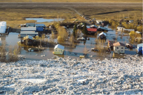
Flooding in Galena, Alaska, May 2013. National Weather Service photo.
Severe late-spring flooding this year along the Yukon River dramatically underscored the importance of accurately predicting snowmelt and river ice breakup in Alaska, when residents of Galena were evacuated with only a moment’s notice as their community was inundated with water and ice on Memorial Day weekend.
CIFAR researchers Katrina Bennett and Jessica Cherry have been working with the National Weather Service’s Alaska-Pacific River Forecast Center (APRFC) to improve the accuracy of snowmelt processes in the models used by the APRFC. This project is supported by the High Latitude Proving Ground, an effort by National Oceanic and Atmospheric Administration (NOAA)-National Environmental Satellite, Data and Information Service (NESDIS) to develop and implement next-generation remote sensing products into the weather and river forecast offices’ modeling protocol.
Bennett, a PhD student at the University of Alaska Fairbanks, has been working with the APRFC to update snow conditions in the temperature-index snow accumulation and melt model SNOW-17 using snow cover data from Moderate Resolution Imaging Spectroradiometer (MODIS) satellite imagery. Currently, snow cover in the model is generated using a sparse observational network and algorithms that calculate mean areal temperature and precipitation. This and other forms of data assimilation with remote sensing products are one way to update information in our modeling systems. Cherry and other members of her research team are trying to balance progress in assimilation and observational data management with a move toward more physically based land surface and systems models.
As hydro-climate systems regimes shift and extreme events become more frequent, it is increasingly important that model predictions simulate the Earth system response accurately. In the Far North, spring snowmelt is the most dramatic hydrologic event of the year, and the mostly likely time for flooding to occur. Given Alaska’s vast territory and sparse ground-based observing networks, remote sensing is an obvious place to turn to improve the prediction of spring snowmelt and river ice breakup. This work relates to NOAA’s Climate Adaptation and Mitigation goal.
Contact: Jessica Cherry, International Arctic Research Center, University of Alaska Fairbanks